PROVINCIAL INCA
ARCHAEOLOGICAL
AND ETHNOHISTORICAL
ASSESSMENT OF THE IMPACT OF THE INCA STATE
EDITED BY MICHAEL A. MALPASSUniversity of Iowa Press Iowa City -1993
Dr. John R. Topic and Theresa Lange Topic
A SUMMARY OF THE INCA
OCCUPATION OF HUAMACHUCO
EDITOR'S INTRODUCTION
The Topics found that while archaeology could have identified the overall historical developments concerning the Inca conquest of this area, subtle political and administrative nuances were provided by the documents, such as the addition of a section of chaupi yunga (middle altitude lowland) territory to the province, and the places of origin of mitima (individuals living outside of their place of origin) settlements. Thus, in a sense, the ethnohistorical information elaborates on the basic archaeological data for the region, rather than the reverse.
Archaeologically, Inca control can be discerned from new settlement types that appear, such as domestic sites, tambos, and mitima settlements, and the main Inca road, which passed through this province and along which these occupations are located. It is hard to differentiate Late Horizon ceramics from Late Intermediate Period ones, reflecting strong continuities in the traditions through time. As in the Huánuco region (to be discussed by Grosboll), the discovery of aryballoid shapes indicates the Inca presence, along with animal head lugs and sometimes distinctive pastes. The discussion of pre-Inca remains is useful for identifying the nature of the Inca impact on the region.
INTRODUCTION
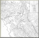
The Incaic province of Huamachuco was located in the northern sierra of Peru, north of Conchucos and Huaylas and south of Cajamarca. It extended from the chaupi yunga zone of the Chicama, Moche, Virú, Chao, and Santa valleys in the west to the Río Marañon in the east and from the Río Crisnejas in the north to Corongo in the south (fig. 2.1). It is not one of the best-known provinces of the Inca empire: although archaeological and ethnohistorical data are available, both are limited in scope.
The archaeological information from Huamachuco is relatively recent and focuses on the area immediately around the modern town. The Huamachuco Archaeological Project has been working in the Huamachuco area since 1981 and has recovered useful information on the Inca presence, though that was not one of the major goals of the project. Previous work by Max Uhle (1900), Theodore D. McCown (1945), and John P. Thatcher (1972) had emphasized earlier time periods and had not in fact been able to identify remains related to Inca control of the province. The archaeological perspective is broadened somewhat by a surface survey of fortified sites that we conducted in the western part of the province from 1977 to 1979. That survey, however, was done before we had acquired much familiarity with the ethnohistorical information. Although Inca-influenced sites exist in that area, we will limit our discussion here largely to comments on the road system.
The ethnohistorical information is rarely very detailed, but it does give an overview of the province. Chronicles frequently mention both the town and the province of Huamachuco, but usually only in passing; these references lead one to expect a fairly substantial Inca presence in the Huamachuco area. Cieza de León (1986: 235-236) reported that the province was large and thickly settled, with great lords and large flocks. He commented also on the presence in the town itself, among the tambos, of two large buildings 22 feet wide and a horse's gallop long. Miguel de Estete (1947: 338) described Huamachuco as a large town in a valley surrounded by mountains, with a good view and good lodgings. Huamachuco was located along the main north-south road, and at a crossroads providing access toward the west to the Moche Valley and eastward to the Río Chusgón, a tributary of the Marañon. Some of the tambos along the main highway are listed by Guaman Poma (1980a: 1003). Garcilaso de la Vega (1966: 342) provides a certain amount of information about Huamachuco, most of it erroneous:
"This tribe indeed was extremely barbarous and cruel in its habits. . . . They had no settled towns, but lived dispersed about the countryside in scattered huts, lacking any form of social organization or order. They lived like beasts." In Garcilaso de la Vega's account, the lord of Huamachuco was delighted to accept the gifts of civilization from the Inca.
Two other useful documents provide a different kind of information. Their broader, provincial-scale information helps to balance the more local nature of the archaeological data. Juan de San Pedro (1992) discusses a number of shrines scattered throughout the province and indicates that there was an oracle in Huamachuco which was worshiped from Cuzco to Quito. Betanzos (1987) provides the fullest description of the destruction of this oracle by Atahuallpa. For the most part, Juan de San Pedro (1992 [1560]) emphasizes the local nature of the religious shrines and practices.
The other document is the Orden sobre el servicio de los tambos del Repartimiento de Guamachuco, written by Gregorio González de Cuenca in 1567. This document, published in Rostworowski de Diez Canseco (1989) and cited here as the González de Cuenca Ordenanza, provides the names of seven towns occupied by mitimas serranos (individuals originally from the highlands but living outside of their place of origin), eight towns occupied by mitímas yungas (individuals originally from the lowlands but living outside of their place of origin), twenty-five towns occupied by the local population, and nine tambos. The local population was divided into four ranked huarangas (an Inca administrative unit of a thousand households), of which the two western huarangas were much larger, and also ranked higher, than the two eastern ones. (This is an interesting point of departure from the Inca ideal, in that clearly the huarangas were not equal in size.) Espinoza (1974: 22, 35) feels that the third-ranked huaranga, Lluicho, was split off from the first-ranked huaranga, Llampa, by Huayna Capac, the eleventh Inca king (died ca. 1527). If this is so, it would be reasonable to assume that fourth-ranked Andamarca was split from second-ranked Huacapongo at the same time. Two other huarangas were formed by the mitimas serranos and mitimas yungas. Finally, although they formed a distinct group, the chaupi yungas populations of at least the Moche Valley, and perhaps the Virú and other adjacent valleys as well, owed allegiance to the curaca (local lord) of Huamachuco.
In this chapter we will discuss the recent archaeological evidence available for Huamachuco and then consider the ways in which this information relates to the ethnohistorical data
 Retornar
Avanzar
Retornar
Avanzar