On the new plan, the main north-south avenue, which is an important feature of the site, appears less clearly than on McCown's map. This is due to the fact that the northern end of the avenue was never finished, although modern field walls now line this portion, and the area around the north gate is represented only by foundations. The avenue. however, was an important consideration in planning the site, since it is oriented almost exactly along the direct line leading from the pass between the two sandstone hills south of the site and the apex of the plain in the north. Plans of Viracochapampa always give the impression that this avenue is off center to the west, whereas this important transportation route is ideally located within the wider context, and it is the topography of the plain that forces most of the architecture off to the east.
No opening has been left at the south gate because excavations there and at the north gate revealed that the foundations of the site boundary wall crossed the avenue. It is most likely that there would have been gates at both ends of the avenue and that these would have been somewhat narrower than the avenue itself. There is a slight angle in the south wall ac the gate. This angle seems to result from the fact that construction of the outer wall started at the gate and proceeded toward the east. Possibly, construction proceeded right around the site in a counterclockwise direction until the south gate was reached again at the level of the second horizontal segment (see "Construction Techniques" below, and Topic and Topic n.d.a: fig.8). This second horizontal segment was then carried east at least to the southeast corner.
The outer wall is 1.8 m wide, but rarely stands more than 1.0 m above the ground surface. It is difficult, there-fore, to know whether there were other entrances in the wall. It is possible that an additional entrance to the site might have existed in the west wall where a possible road (already mentioned) skirts that side of the site. It would have been reasonable to have an entrance in the east wall, at least during construction, to facilitate access to the closest source of water, the Rio de las Cuevas 300 m to the east. Interior site walls define spatial divisions of greater or lesser size and complexity. These spatial divisions can be described in terms of enclosures, buildings, and access routes. In turn, the spatial units combine to form patio groups and "architectural areas."
The basic division of the site is into enclosures by means of walls that are normally less than 2 m high. These enclosures do not seem to conform to any standard size or shape and are usually quite empty. One major exception is the large enclosure along the middle of the east side that contains two small, isolated buildings. Both of these buildings are severely ruined now, and survey in the plowed fields surrounding them revealed only the occasional, very eroded sherd. It should be noted that the enclosures at Viracochapampa are much less rigidly organized than the enclosures at other Huari provincial centers (see Anders, Schreiber, and McEwan, this volume).
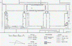
A building is defined as a space enclosed by a single unified facade and roof. There are two major types of buildings at Viracochapampa: niched halls and galleries. These will be described in more detail below, but it is worth noting a few points at this time. On the map (Fig. 2) niched halls appear as large rectangular buildings with rounded interior corners. These niched halls are a very specific and diagnostic type of building (see Figs. 3-5) and are clearly an important constituent of the architecture at Viracochapampa. Although two similar buildings have recently been reported at Huari itself (Isbell, personal communication), the better known equivalents of the Viracochapampa niched halls are at Pikillacta (McEwan, this volume). I would estimate that there are only fifteen possible niched hall equivalents at Pikillacta, while there are nineteen niched halls at Viracochapampa. Moreover, the main architectural block of Pikillacta is much larger (about 1.4 times) and more densely built up than Viracochapampa. In contrast, structures similar to niched halls are relatively common at the site of Marca Huamachuco.
The gallery, the second major type of building, is characterized by its "great narrowness, great height, and very great length" (McCown 1942: 252). Although McCown's description was meant to apply to buildings of the nichedhall type at the site of Marca Huamachuco, he recognized that the type graded into what I would more strictly define as galleries. At Viracochapampa galleries are usually at least six times longer than they are wide, two stories tall, and arranged around the perimeter of an enclosure. When two perpendicular galleries abut, the point of abutment is sometimes formed by a diagonal end wall and sometimes by a straight wall (Fig. 3). Other galleries consist of two long rooms built parallel to each other and under the same roof (Fig. 4). The closest comparisons for these diagonal end walls and parallel roomed galleries is again at Pikillacta (McEwan, this volume).
Access routes include the main avenue, corridors, passageways, and doorways. All these access routes, except doorways, were probably unroofed. There is only one main avenue. Corridors are long halls providing access between several different enclosures. There are few recognizable corridors, the best example being located just west of Unit A. Another possible corridor leads from the main avenue to the northwest corner of the central plaza. Passageways are formed by gaps between adjacent buildings and allow access between two enclosures. Good examples of passageways are located in Units A and B. A doorway is any prepared opening in a wall that allows access through the wall. There are numerous examples of doorways at Viracochapampa that allow access into and out of buildings, between the rooms of a building, and between different enclosures.
By combining enclosures, buildings, and access routes, larger architectural groupings can be defined. A patio complex is an enclosure in which buildings surround three or four sides of, and open onto, an unroofed space. An architectural area is a more general grouping of several adjacent enclosures with structures. Four such areas can be defined tentatively.
The clearest examples of architectural areas are probably Units A and B. In these two units, access can be traced not only between the individual patio complexes, but also between the patios and some adjacent enclosures, especially those immediately behind the niched halls. The arrangement of passageways between adjacent patio complexes shows clear similarities to the Moraduchayuc sector at Huari (Isabell et al., this volume). The arrangement of galleries and niched halls, however, is most similar to parts of Sector 1 at Pikillacta (McEwan, this volume). Together. patio complexes and "backyard" enclosures associated with Units A and B occupy a considerable portion of the site ( 28,190 m2 or 8.6 %) and contribute much of the impact of the site plan.
Another area that enhances the impression of orthogonal planning conveyed by the site map is the central plaza While we were unable to securely identify doorways opening onto the plaza, we suspect that both of the large nichec halls were accessible from the plaza and, in addition, a corridor leads around the southern niched hall to a series of galleries. Some of the buildings along the west side of the plaza were probably also accessible, while access to buildings on the east side of the plaza is more problematical. The arrangement of niched halls on opposite sides of the central plaza is most simiIar to structure 33-2B at Pikillacta. In addition, the corridor leading to one corner of the plaza is similar to structure 39-2B at that site (McEwan, this volume). The central plaza and buildings immediately accessible to it occupy at least 5% of the total site area.
Access patterns are less clear in the large northeast sector of the site. This area includes the large rectangular niched hall flanked by the two smaller square niched halls immediately east of the plaza. All three of these niched halls probably opened onto the large enclosure with two isolated buildings in the middle of the east side of the site.
Along the southern side of this enclosure are two more niched halls set in small enclosures with adjacent galleries that also seem to be part of the northeast sector. Finally, there are three more niched halls in the area northeast of Unit B. Two of these are set in courts and definitely open to the east, while one is isolated in a large enclosure and is not aligned with the other two. This northeast sector, which does not include the galleries and small buildings east of the central plaza but does include the two large enclosures (25.5%), occupies 28.8% of the total site area. It seems to me that there is a distinct similarity between this sector and Sector 3 at Pikillacta (McEwan, this volume).
There are two additional niched halls at the site. One is located in a patio complex west of the avenue and could represent the core of a fifth architectural area. The other is in an enclosure off the southwest corner of the plaza. These two complexes occupy only 1% of the site area. Approximately 53% of the site is occupied by the remaining empty enclosures. This leaves only about 3.6% as "filler" architecture-galleries, sometimes arranged around patios, corridors, courts, and so on-that cannot be clearly related to the major architectural units.
Each of the four major architectural areas consists of an association between large open areas, níched halls, and galleries. On a .more detailed level, however, these elements are combined into many different forms. There is a tendency for the niched halls to occur in repetitive groupings, but they can be either aligned end-to-end or opposed across the central plaza. Galleries usually surround three or four sides of a patio unit, but may either be combined with a niched hall or form a separate patio complex. Large open spaces may occur in front of or behind niched halls, or both. Doorways of niched halls can be oriented to the east, north, or south but not, apparently, to the west.
A unique feature at Viracochapampa may have been of great importance in planning the site. This feature is a long mound on the west side of the plaza, artificially raised 2-3 m above the surrounding surfaces. There are few structures on the mound; the most important is a small, almost square, well-constructed building whose interior also appears to be raised by artificial fill.
The longitudinal axis of the mound, projected to the east. passes through the center of the site. Here, the center of the site refers to the point of intersection of diagonals connecting the corners of the site (Fig. 2, *2). While this point lies within the plaza, it is not in the center of the plaza. When the center of the plaza is located in the same manner by drawing diagonal lines between the corners (Fig. 2, *3), the axis of the mound can be seen to pass through the center of the plaza. Projecting the longitudinal axis of the mound further east, the line apparently passes through the doorway of the large niched hall flanked by two smaller niched halls east of the plaza (Fig. 2, *4). This doorway is also located approximately in the center of the sector of the site lying east of the avenue. The axis also bisects the isolated room in the east enclosure. Projected to the west the axis passes through the center of the sector of the site lying west of the avenue (Fig. 2, *I).
The apparent existence of this axis underscores the importance of the mound and its accompanying structure. It should be noted that this east-west line does not actually bisect the site as a whole, but does bisect the plaza into north and south halves. The only other apparent symmetry within the site created by this axis is that the number of niched halls north of the line is the same as the number south of the line. This last observation should, however, be qualified by pointing out once again that the site was never finished and that the map may show only a portion of the intended architecture. The possible importance of this axis within the regional context of Huamachuco needs to be explored by further fieldwork.
An apparently much less important north-south axis can be created in a similar manner. In this case, a line connecting the centers of the two niched halls on the north and south sides of the plaza also passes through the center of the plaza and also runs along the east wall of the enclosures forming Unit A. I will argue below that both axes were important in laying out the site.
 Retornar
Avanzar
Retornar
Avanzar