Carpaico
A Survey by Carpaico
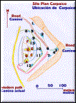
Carpaico is a prehistoric fortified place, located in the top of the hill known as Cerro Carpaico; hence the site name. It is located in the north highlands of Peru, in the Province of Otuzco, Department of La Libertad. The site is situated at an elevation of 3300 m. About 1,3 km North is the site of Piura.
The cerro is roughly triangular in shape. The three sides of the cerro face South, East and West. Cerro Carpaico is flanked by quebradas which run South to the Moche River, on the Northeast and northwest. To the south, there is a clear view of the site of Huacaday, and to the southwest, the Moche River. To the north, there is a clear view of Cerro Piura, and a partial view of Cerro Rogoday beyond. The natural flora occurring in the area today includes mainly grasses, cacti, and low xerophytics.
The location of the site on the top appears to have a strategic importance. Material and architectural remains at the site suggest that Carpaico may have an administrative centre during the time of occupation, established as a gateway between major coastal and highland polities. To the extent, a number of defensive features at the site are relevant. The particular location of the site was important to its administrative function. Carpaico was made readily accessible from the more distant parts of the polity. This is important, because if Carpaico was in fact the administrative centre of the area, then it would have been necessary to provide access to and from the site for the citizens of the area. The top of Carpaico was basically flat which was an important feature in that it provided a controlled area within the site where formal plazas were erected to facilitate economic transactions and administrative functions. The main water source of Carpaico appears to have a quebrada located about 0,5 km Northeast of the site. There is a small collecting basin in the quebrada in which water is available year round. External access to Carpaico is gained from two directions; North and South. The site of Huacaday exists immediately to the south of Carpaico, some 2 km distance.
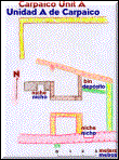
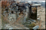
The site is roughly triangular in shape, oriented in a North-South direction. The perimeter of the site is bounded by a series of concentric walls. There are 13 structural simples (numbers 1 to 13) and one parapeted bastion on the East and South slopes. In addition, there are 6 structural complexes (letters A to F) on the summit of the cerro. In terms of overall dimensions, the site of Carpaico is 240 metres North-South. The site measures 200 metres East-West.
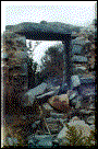
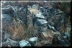
The building material are mainly stone and mud. The cut stone may be divided into two classes: "finely cut stone" and "crudely cut stone". The finely cut stone may be further divided by size: small, for wall construction; and large (lintels) for roof construction. The crudely cut stone is found in numerous structures and in most terrace walls at Carpaico. The presence of obvious social differentiation is unique at Carpaico, and is probably reflective of the importance of the trade route passing directly through Carpaico undoubtedly stimulated the economic and political growth of the site. The prestigious architecture at the summit of Carpaico is probably representative of the administrative and governing officials who resided at the site.
A special thanks to the Doctor John Topic of the Trent University, Canada.
This is a condensed of the Gary Coupland, Department of Anthropology, 1979.
Fotos: Prof. Carlos Moquillaza
Un viaje por Carpaico
Carpaico es una fortificación prehistórica, ubicada en lo alto de una montaña conocida como Cerro Carpaico; de aquí toma su nombre. Está ubicado en las serranías norteñas del Perú, en la provincia de Otuzco, departamento de La Libertad. El lugar esta situado en una altitud de 3300 metros sobre el nivel del mar. A 5 kilómetros de aquí está el lugar llamado Piura.
El cerro es aproximadamente de forma triangular. Las tres caras del cerro dan hacia el Sur, Este y Oeste. Cerro Carpaico esta bordeado por quebradas las cuales van al sur del río Moche, en dirección Noreste y noroeste. Hacia el Sur se observa claramente el lugar denominado Huacaday y hacia el Suroeste el río Moche. Para el norte existe una clara vista del cerro Piura y una vista parcial del cerro Rogoday al fondo. La vegetación natural que existe en el área incluyen principalmente pastos, cactus y xerofitas menores.
La localización de este lugar en lo alto parece tener una importancia estratégica. Los materiales y restos arquitectónicos de este lugar sugieren que Carpaico pudo ser un centro administrativo durante el tiempo de ocupación, establecido como una puerta de entrada entre las principales zonas políticas costeñas y serranas. Por extensión, son importantes por las características defensivas que tenían, la localización particular de este sitio fue importante para una función administrativa. Carpaico fue construido para ser accesible a los mayores lugares de este dominio. Esto es importante porque si Carpaico fue de hecho el centro administrativo de esta área, luego este pudo ser necesario para proveer un acceso a y desde este lugar a todos los ciudadanos de esta área. La cima de Carpaico fue básicamente plana la cual es una importante característica que provee un área controlada dentro del lugar donde forman plazas, las cuales fueron construidas para facilitar las transacciones económicas y las funciones administrativas. La principal fuente de Carpaico parece haber sido una quebrada localizada a medio kilómetro ubicada al Noreste de este lugar. Existe una fuente en la quebrada disponible todo el año. El acceso externo a Carpaico es logrado desde dos direcciones, Norte y Sur. El lugar de Huacaday existe inmediatamente al Sur de Carpaico, a 2 kilómetros de distancia.
El lugar es aproximadamente de forma triangular, orientado en una dirección Norte Sur. El perímetro de este sitio está bordeado por una serie de paredes concéntricas. Existen trece estructuras simples (numeradas del 1 al 13) y un bastión parapetado en las pendientes este y sur. Además existen 6 estructuras complejas (letras A a la F) en la cumbre del Cerro. Las dimensiones totales de este lugar son 240 metros en dirección Norte Sur y 200 metros en dirección Este Oeste.
Los materiales de construcción son principalmente de piedra y barro. La piedra labrada puede ser dividida en dos clases: "piedra labrada fina" y "piedra crudamente labrada". La piedra labrada fina puede ser además dividida por tamaño: pequeña, para las paredes; y grandes, para los techos. La piedra crudamente labrada es encontrada en numerosas estructuras y en mayoría de terrazas de Carpaico. La presencia de una obvia diferenciación social es única en Carpaico y es probablemente reflejo de la importancia de la ruta comercial que pasa directamente a través de Carpaico, indudablemente estimulada por un crecimiento económico de este lugar. La arquitectura prestigiosa en la cumbre de Carpaico es probablemente representativo de la administración y gobierno que residían en este lugar.
Un especial agradecimiento al Dr. John Topic de la Universidad de Trent, Canadá.
Este es un condensado de Gary Coupland, Departamento de Antropología, 1979.
 Página Anterior