« Arqueología » Viracochapampa
Viracochapampa is located about 2.5 km north of the modern town of Huamachuco. The modern road between Huamachuco and Viracochapampa follows an ancient foot-path. As it leaves Huamachuco it climbs steeply to a pass located on the western slopes of Cerro Sazon and only about 500 m. west of that site.
From the pass the road descends straight to the south gate of the site. Along this descent, the road is flanked on both sides by two low sandstone hills on which can still be seen the quarry pits from which most of the stone for the construction of the site was obtained. About 10 m south of Viracochapampa's outer wall, erosion has revealed the remains of a canal running roughly perpendicular to the road. Here, the canal has a slightly trapezoidal cross section (about 35 cm wide at the top, 42 cm wide at the bottom, and 35-40 cm deep). It was lined on the sides and top with tabular slabs of sandstone, but was unlined on the bottom.
This part of the canal is similar to other Huari canals (McEwan, this volume; Anders, this volume), but most similar to the canal at Jincamocco (Schreiber, this volume) that is also unlined on the bottom. The canal can be traced upslope for almost a kilometer to the southeast as it curves around the foot of a hill. For most of this distance it is uncovered and the stone lining is more roughly constructed; the bottom of the canal is never lined. At onepoint it is crudely cut through a bedrock outcrop at a steeper gradient than normal along its course.
Excavations at two points along the canal showed that the stratigraphic profile within the canal was identical to that outside the canal. This suggests that the lining stones had been placed in narrow trenches but that the channel it self had never been dug out. There was no evidence that the canal was ever used, and in many places it appeared that construction of the canal was still in progress when it was abandoned.
Perhaps related to the canal construction were a few poorly preserved structures located along the canal route, which may have housed workers. These were not excavated, and the few surface ceramics did not permit dating.
Other possible structural remains that lie outside Viracochapampa itself are two quadrilateral enclosures. One of these is about 30 m on a side and is located about 400 m west of the southwest corner of the site. The other is approximately 25 by 65 m and is separated from the southwest corner only by a road or path 12 m wide. These enclosures now have no standing walls, but are outlined by piles of stone rubble. No associated ceramics were found.
Viracochapampa was undoubtedly associated with a major road running north and south through the Andean chain. The most likely route followed by this road was along the road from modern Huamachuco to the south gate, down the main avenue of the site, and out the north gate. An alternate route would skirt around the west side of the site, as a modern path descending to the Rio Grande de Huamachuco does. Still another possibility is a path that diverges just south of the site and crosses the Rio de las Cuevas heading northeast; this path was apparently the Inca route (Hyslop 1984). There is also the trace of a wall extending southwest from the southwest corner of the site which may represent still another ancient road. It is quite likely that a number of paths or roads would have led to the site.
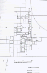
Although Viracochapampa is oriented approximately to the cardinal directions, this orientation may well have been determined as much by topography as by any attempt to align the site with the cardinal directions (cf. McCown 1945: 267). The site straddles almost the full width of a gently sloping plain. This plain is roughly triangular in shape, with its base at the two sandstone hills in the south and its apex about 1 km north of the site. The plain is composed of a thick deposit of coarse sediment of probable late Tertiary or early Quaternary date, overlain by 1-3 m of sandy clay deposited by mudslides in the Pleistocene and Holocene (Geurts 1982).
In conforming to the topography of this plain, the site has a somewhat trapezoidal shape, broader at the south than at the north, rather than the rectangular shape usually attributed to it. McCown (1945: 267), for example, gives dimensions of 580 m east-west by 565 m north-south, while Uhle (field notes) gives measurements of 618 by 566 m. Our measurements, derived from air photographs that probably incorporate some distortion, are: north wall, 566 m; south wall, 581 m; east wall, 564 m; and west wall, 574 m.
It is worthwhile at this point to examine some of the differences between our map (Fig. 2) and that of McCown (1945: fig. 13). McCown's map was constructed using a compass and tape measure, while ours was traced from air photographs and later repeatedly checked and corrected in the field. Where he actually gives measurements of buildings, they are likely to be more accurate than measure�ments taken directly from either map; the dimensions he gives for the site, for example, are probably based on measurements along the south and east walls, and they agree well with our map.
The most densely built-up areas of the site are the most interesting areas, but they are also heavily overgrown with thorny bushes and difficult to map. Often we had to penetrate areas by cutting small tunnels in the vegetation with machetes, and McCown (1945: 269) apparently had similar problems. This is not an ideal situation in which to accurately map a site, and many minor inconsistencies between the two maps can be ascribed to the adverse conditions. We are impressed by the accuracy of McCown's work on all the sites in the Huamachuco area, and refer to his maps continually. We have made changes in the maps only when we feel justified in doing so.
By its very nature, a map incorporates a certain degree of interpretation. The major interpretation incorporated into the new Viracochapampa map is that the construction of the site was never finished (Topic and Topic n.d.b; Topic. Topic, and Carmichael n.d.). On the map, walls are indicated as complete (standing more than 2 m above the ground surface or incorporating a row of corbels), incomplete, or as foundations only; walls that appear to be modern are not shown. McCown (1945: 267) was justifiably impressed with the unity of planning demonstrated by the site (cf. Belaúnde Terry 1961) and at times seems to have extended or extrapolated walls in conformity with principles for orthogonal planning. Nevertheless, both in terms of the plans themselves and detailed observations not shown on the maps, there is very close agreement between our work and McCown's.
 Retornar
Avanzar
Retornar
Avanzar